Swyre Head, Lulworth

Swyre Head, Lulworth is a hill and sea cliff which lies on the Jurassic Coast between Bat's Head to the west and Durdle Door to the east, close to Lulworth (further to the east) in Dorset, England. It is located approximately 8 miles (12.9 km) east of Weymouth and 14 miles (22.5 km) west of Swanage.
Swyre Head, Lulworth, lies only about 8.5 miles (13.7 km) west of another Swyre Head, which is located close to the village of Kingston and which is the highest point on the peninsula known as the Isle of Purbeck.
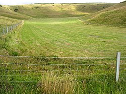
The cliffs of Swyre Head, Lulworth, are of chalk and are steep, with grassland and a footpath above. The footpath runs close to the cliff edge and is steeply undulating. Despite the steepness, it is popular for walks[1][2] and the scenery is spectacular.[3][4][5]
Between Swyre Head and the natural rock arch of Durdle Door is a small dry valley known as Scratchy Bottom.
References
- ^ Swyre Head & Durdle Door walks.
- ^ Two walks west of Durdle Door.
- ^ John Dyason, Photograph: Swyre Head with Bat's Head beyond from Durdle Door, South West Coast Path.
- ^ Coast at Bat's Head and Swyre Head, near Durdle Door, Dorset, England, AllPosters.com.
- ^ Photo from Swyre Head and Durdle Door from Bat's Head, Panoramio.
50°37′26″N 2°17′06″W / 50.6238°N 2.2851°W / 50.6238; -2.2851
- v
- t
- e
| Chesil Beach | |
|---|---|
| Isle of Portland | |
| Weymouth |
- Furzy Cliff
- Jordan Hill
- Bowleaze Cove
- Broadrock
- Redcliff Point
- Black Head
- Osmington Mills
- Bran Point
- Perry Ledge
- Ringstead
- Ringstead Bay
- White Nothe
- Chaldon Hill
- Bat's Head
- Swyre Head
- Scratchy Bottom
- Durdle Door
- Man o' War Cove
- St Oswald's Bay
- Pinion Rock
- Dungy Head
- Stair Hole
- Lulworth Cove
- Lulworth Ranges
- Purbeck Monocline
- Bindon Hill
- Fossil Forest
- Mupe Bay
- Arish Mell
 | This Dorset location article is a stub. You can help Wikipedia by expanding it. |
- v
- t
- e


