Subdivisions of Gran Colombia
The Republic of Gran Colombia was a former independent country in northern South America, a post-Spanish colonial country that existed from 1819 to 1831. Its initial subdivisions, created in 1820, were revised and expanded in 1824 to 12 departments.
1820 Departments

The initial country subdivision of Gran Colombia was into three departments, without larger districts or smaller provinces. They were:
- Cundinamarca Department
- Quito Department
- Venezuela Department
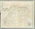
1824 districts, departments, and provinces

Northern District
The Northern District (Spanish: Distrito del Norte) was in present-day Venezuela and Brazil. Its departments and provinces were:
- Apure Department: 2 provinces — Barinas Province and Achaguas Province.
- Orinoco Department: 4 provinces — Cumaná Province, Barcelona Province, Guayana Province and Margarita Province.
- Venezuela Department: 2 provinces — Caracas Province and Carabobo Province.
- Zulia Department: 4 provinces — Maracaybo/Maracaibo, Coro Province, Mérida Province and Trujillo Province.
Central District
The Central District (Spanish: Distrito del Centro) was in present-day Colombia and Panama. Its departments and provinces were:
- Boyaca Department: 4 provinces — Tunja Province, Casanare Province, Pamplona Province, and Socorro Province.
- Cauca Department: 4 provinces — Popayán Province, Buenaventura Province, Chocó Province, Pasto Province.
- Cundinamarca Department: 4 provinces — Bogotá Province, Antioquia Province, Mariquita Province, Neiva Province.
- Isthmus Department (now Panama): 2 provinces — Isthmus Province and Veraguas Province.
- Magdalena Department: 3 provinces — Cartagena Province, Riohacha Province, Santa Marta Province.
Control of a strip of the Mosquito Coast along the Atlantic Ocean (in present-day Costa Rica and Nicaragua) was disputed with the British and the Federal Republic of Central America.[citation needed]
Southern District
The Southern District (Spanish: Distrito del Sur) was in present-day Ecuador, and north of Marañón River in present-day Perú. Its departments and provinces were:
- Azuay Department: 3 provinces — Cuenca Province, Loja Province, Jaén de Bracamoros y Maynas Province.
- Guayaquil Department: 2 provinces — Guayaquil Province and Manabi Province.
- Ecuador Department: 3 provinces — Pichincha Province, Chimborazo Province and Imbabura Province.
Maps of subdivisions
-
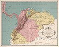 3 departments in 1820: Quito, Cundinamarca, Venezuela
 -
 12 departments in 1824
 -
 Gran Colombia in 1827


See also
- Provinces of Gran Colombia
- Departments of Colombia — in present day country.
External links
- Ley de División Territorial de la República de Colombia—(in Spanish)
- Historia territorial de Colombia—(in Spanish)
Wikimedia Commons has media related to Maps of the Gran Colombia.
- v
- t
- e
 Gran Colombian independence
- Viceroyalty of New Granada (1717–1723), (1739-1819)
- Captaincy General of Venezuela (1777–1821)
- Peninsular War in Spain (1808–1814)
history
- Luz de América (1809)
- First Republic of Venezuela (1810–12)
- Colombian Declaration of Independence (1810)
- Venezuelan Declaration of Independence (1811)
- United Provinces of New Granada (1811–16)
- Second Republic of Venezuela (1813–14)
- Third Republic of Venezuela (1817–19)
- Gran Colombia (1819–31) (Ecuador, 1830
- Venezuela/Republic of New Granada, 1831)
history
| 1812–16 |
|
|---|---|
| 1819–23 |
|
figures
figures
- Carmañola Americana (1797)
- Decree of War to the Death (1813)


